Arvada, Colorado
| City of Arvada, Colorado | |
|---|---|
| — City — | |
| Nickname(s): Celery Capital of the World Home of the lowest ZIP Codes in Colorado |
|
 |
|
| Coordinates: | |
| Country | |
| State | |
| Counties[1] | Jefferson County Adams County |
| Settled | 1859[2] |
| Platted | 1870-12-01[2] |
| Incorporated | 1904-08-24[2][3] |
| Named for | Hiram Arvada Haskin |
| Government | |
| - Type | Home Rule Municipality[1] |
| - Mayor | Bob Frie[4] |
| - City Manager | Craig Kocian[5] |
| Area | |
| - Total | 32.9 sq mi (85.1 km2) |
| - Land | 32.7 sq mi (84.6 km2) |
| - Water | 0.2 sq mi (0.5 km2) |
| Elevation | 5,344 ft (1,662 m) |
| Population (2009) | |
| - Total | 108,172 |
| - Density | 3,255/sq mi (1,257/km2) |
| Time zone | MST (UTC-7) |
| - Summer (DST) | MDT (UTC-6) |
| ZIP codes | 80001-80007 and 80403[6] |
| Area code(s) | Both 303 and 720 |
| FIPS code | 08-03455 |
| GNIS feature ID | 0204709 |
| Highways | I-70, I-76, SH 72, SH 93, SH 95, SH 121 |
| Website | City of Arvada |
|
Eighth most populous city in Colorado |
|
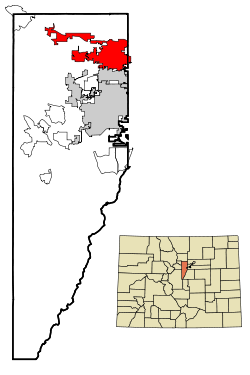
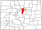
The City of Arvada (pronounced /ɑrˈvædə/) is a Home Rule Municipality located in Jefferson and Adams counties in the Denver-Aurora-Broomfield, CO Metropolitan Statistical Area of the U.S. State of Colorado. Olde Town Arvada is located 7 miles (11 km) northwest of the Colorado State Capitol in Denver. The United States Census Bureau estimates that the population of Arvada was 108,172 on July 1, 2009.[7] Arvada is the eighth most populous city in the state of Colorado and the 235th most populous city in the United States.
Contents |
History
The first documented discovery of gold in the Rocky Mountain region occurred on June 22, 1850, when Lewis Ralston, a Georgia prospector headed for the California gold fields, dipped his sluice pan into a small stream near its mouth at Clear Creek.[2] Ralston found about 1/4 ounce (6 g) of gold then worth about five dollars. Ralston's companions named the stream Ralston's Creek in his honor, but they all left the next morning, drawn by the lure of the California gold fields.
During the Pike's Peak Gold Rush in 1858, Ralston brought another group of prospectors back to the site of his first discovery. The placer gold in the area soon played out, but hard rock deposits of gold were found in the mountains to the west. Some of the miners abandoned their search for gold and returned to farm the rich bottom land along Ralston Creek and Clear Creek. They found an eager market for their crops among other gold seekers. The Territory of Colorado was formed on February 28, 1861, and the farms in the valley expanded to feed the growing population of the region.
In 1870, the Colorado Central Railroad laid tracks through the area on its route from Golden to link up with the Kansas Pacific Railroad and the Denver Pacific Railroad at Jersey Junction, 3 miles (5 km) north of Denver. On December 1, 1870, Benjamin F. Wadsworth and Louis A. Reno platted the Ralston Point townsite along the railroad. To avoid confusion with other communities along Ralston Creek, Ralston Point was soon renamed Arvada in honor of Hiram Arvada Haskin, brother-in-law of settler Mary Wadsworth.[8] Benjamin Wadsworth became the first postmaster of Arvada. Colorado was granted statehood on August 1, 1876, and the Town of Arvada was formally incorporated on August 14, 1904. A vibrant agricultural community, Arvada claimed the title "Celery Capital of the World."
Arvada grew rapidly during the latter half of the 20th century as a suburb of nearby Denver, the state capital. Arvada became a Statutory City on October 31, 1951, and a Home Rule Municipality on July 23, 1963. By the end of the millennium, the population of Arvada exceeded 100,000.
Missionary shooting
On December 9, 2007, Matthew J. Murray walked into the Youth With a Mission Center in Arvada and, after he was refused his request to stay overnight, opened fire and killed two people, injuring two more. A memorial was held the following Wednesday, December 12, in which Youth With a Mission leaders forgave Murray's family for what happened.[9]
Government
The City of Arvada is a Home Rule Municipality with a council-manager form of government. The Arvada City Council has seven members: a mayor and two councilmembers elected at large, and four councilmembers elected from council districts.
| Office | Incumbent |
|---|---|
| Mayor | Bob Frie |
| Councilmember At-large | Don Allard |
| Councilmember At-large | Marc Williams |
| Councilmember, District One | Rachel Zenzinger |
| Councilmember, District Two | Mark McGoff |
| Councilmember, District Three | Shelley Cook |
| Councilmember, District Four and Mayor Pro Tem | Bob Dyer |
The City Council selects the city manager. The Arvada City Manager is Craig Kocian.[5]
Geography
Arvada is located at (39.819962, -105.110975)[10].
According to the United States Census Bureau, the city has a total area of 32.8 square miles (85.1 km²).84.6 km²; (32.7 sq mi) of it is land and 0.2 square miles (0.5 km²) of it (0.58%) is water.
Transportation
Arvada is the western terminus of Interstate 76, which begins at the intersection of Interstate 70 and State Highway 121. Other state highways in Arvada include State Highway 72, State Highway 93, and State Highway 95. Major highways near Arvada include Interstate 25, Interstate 270, U.S. Highway 36, and U.S. Highway 287.
The Amtrak California Zephyr passes through the City of Arvada westbound each morning and eastbound each evening. This route through the scenic heart of the Rocky Mountains is one of the most popular rail routes in the United States. Full Amtrak passenger and parcel service is available at the nearby Denver Union Station.
The Denver Regional Transportation District (RTD) currently serves Arvada with seven local bus routes (31, 51, 52, 72, 76, 80, and 100), four express bus routes (55X, 58X, 72X, and 80X), and one regional bus route (GS). RTD plans to provide Arvada with a commuter rail Gold Line along the old Colorado Central Railroad route (now operated by the Union Pacific Railroad) by 2015.
Arvada is served by Denver International Airport and nearby Rocky Mountain Metropolitan Airport.
Demographics
| Historical populations | |||
|---|---|---|---|
| Census | Pop. | %± | |
| 1910 | 840 |
|
|
| 1920 | 915 | 8.9% | |
| 1930 | 1,276 | 39.5% | |
| 1940 | 1,482 | 16.1% | |
| 1950 | 2,359 | 59.2% | |
| 1960 | 19,342 | 719.9% | |
| 1970 | 49,844 | 157.7% | |
| 1980 | 84,578 | 69.7% | |
| 1990 | 89,235 | 5.5% | |
| 2000 | 102,153 | 14.5% | |
As of the census[11] of 2000, there were 102,153 people, 39,019 households, and 27,742 families residing in the city. The population density was 3,128.1 people per square mile (1,207.6/km²). There were 39,733 housing units at an average density of 1,216.7/sq mi (469.7/km²). The racial makeup of the city was 91.04% White, 0.66% African American, 0.65% Native American, 2.17% Asian, 0.07% Pacific Islander, 3.08% from other races, and 2.34% from two or more races. Hispanic or Latino of any race were 9.82% of the population.
There were 39,019 households out of which 34.2% had children under the age of 18 living with them, 57.5% were married couples living together, 9.7% had a female householder with no husband present, and 28.9% were non-families. 23.1% of all households were made up of individuals and 7.7% had someone living alone who was 65 years of age or older. The average household size was 2.60 and the average family size was 3.07.
In the city the population was spread out with 26.2% under the age of 18, 7.8% from 18 to 24, 30.4% from 25 to 44, 24.9% from 45 to 64, and 10.7% who were 65 years of age or older. The median age was 37 years. For every 100 females there were 96.0 males. For every 100 females age 18 and over, there were 92.9 males.
The median income for a household in the city was $55,541, and the median income for a family was $63,273. Males had a median income of $42,126 versus $30,802 for females. The per capita income for the city was $24,679. About 3.5% of families and 5.2% of the population were below the poverty line, including 6.4% of those under age 18 and 6.1% of those age 65 or older.
Economy
Arvada is largely a commuter town to Denver and Boulder. The primary retail corridors are along Wadsworth Boulevard, 52nd Ave and Ralston Road.
Sister cities
Arvada has three sister cities, as designated by Sister Cities International:
.svg.png) Mechelen, Belgium
Mechelen, Belgium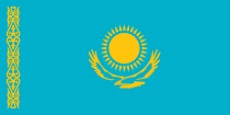 Kyzylorda, Kazakhstan
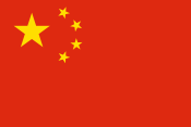 Jinzhou, China
Notable residents
- Robert Louis "Bob" Beauprez (1948- ), former U.S. Congressman
- Rick Carelli (1955- ), NASCAR truck racer
- James D. Conley (1955- ), Roman Catholic prelate
- Clive Cussler (1931- ), popular author and automobile collector
- Bob Enyart (1959- ), talk show host
- Nick Fazekas (1985- ), professional basketball player
- Sara Gagliardi (1958- ), nurse and state legislator
- Roy Halladay, (1977- ), Major League Baseball pitcher and Cy Young Award recipient
- Evie Hudak, (195?- ), state legislator
- Michael Keen, (1980- ), artist
- Joe King (1980- ), composer, guitarist, vocalist, and co-founder of The Fray
- Marty Lindsey (née Marty Mariani) (1970- ), actor - imdb
- Aaron Rothe (198?- ), keyboardist for Drop Dead, Gorgeous and Sonny Moore
- Karl Rove (1950- ), political strategist and White House Deputy Chief of Staff
- Isaac Slade (1981- ), composer, pianist, lead singer, and co-founder of The Fray
- Nick Stabile (1971- ), actor
- John Charles Vivian (1889–1964), 30th Governor of the State of Colorado
- Matt Weatherford (1967- ), online film critic
- Dave Welsh (1984- ), lead guitarist for The Fray
- Ben Wysocki (1984- ), percussionist for The Fray
See also
- Colorado cities and towns
- Colorado municipalities
- Arvada Center for the Arts and Humanities
- Colorado municipalities
- Colorado counties
- Colorado history
- Pike's Peak Gold Rush
- Colorado metropolitan areas
- Denver-Aurora-Broomfield, CO Metropolitan Statistical Area
- Denver-Aurora-Boulder, CO Combined Statistical Area
- North Central Colorado Urban Area
- Front Range Urban Corridor
- Colorado school districts
- Jefferson County R-1 School District
- Westminster 50 School District
- Apex Park and Recreation District
- United States Fish & Wildlife Service
- Rocky Flats National Wildlife Refuge
- Two Ponds National Wildlife Refuge
References
- ↑ 1.0 1.1 "Active Colorado Municipalities". State of Colorado, Department of Local Affairs. http://www.dola.state.co.us/dlg/local_governments/municipalities.html. Retrieved 2007-09-01.
- ↑ 2.0 2.1 2.2 2.3 "Arvada History" (HTTP). City of Arvada, Colorado. http://arvada.org/community/history.php. Retrieved 2007-08-20.
- ↑ "Colorado Municipal Incorporations". State of Colorado, Department of Personnel & Administration, Colorado State Archives. 2004-12-01. http://www.colorado.gov/dpa/doit/archives/muninc.html. Retrieved 2007-08-18.
- ↑ 4.0 4.1 "City Council Members" (HTTP). City of Arvada, Colorado. http://arvada.org/government/index.php?pid=1282. Retrieved 2007-11-15.
- ↑ 5.0 5.1 "City Manager's Office". City of Arvada, Colorado. http://arvada.org/government/index.php?pid=1014. Retrieved 2007-11-15.
- ↑ "ZIP Code Lookup" (JavaScript/HTML). United States Postal Service. August 18, 2007. http://zip4.usps.com/zip4/citytown.jsp. Retrieved August 18, 2007.
- ↑ "Annual Estimates of the Population for All Incorporated Places in Colorado" (CSV). 2009 Population Estimates. U.S. Census Bureau, Population Division. June 2010. http://www.census.gov/popest/cities/tables/SUB-EST2009-04-08.csv. Retrieved June 29, 2010.
- ↑ "Profile for Arvada, Colorado". ePodunk. http://www.epodunk.com/cgi-bin/genInfo.php?locIndex=9337. Retrieved 2010-06-15.
- ↑ Holusha, John (2007-12-09). "Gunman Kills 2 at Missionary Center Near Denver". The New York Times. http://www.nytimes.com/2007/12/09/us/09cnd-shoot.html?hp. Retrieved 2007-12-09.
- ↑ "US Gazetteer files: 2000 and 1990". United States Census Bureau. 2005-05-03. http://www.census.gov/geo/www/gazetteer/gazette.html. Retrieved 2008-01-31.
- ↑ "American FactFinder". United States Census Bureau. http://factfinder.census.gov. Retrieved 2008-01-31.
External links
- City of Arvada website
- Jefferson County website
- Rocky Flats National Wildlife Refuge website
- Two Ponds National Wildlife Refuge website
 |
Rocky Flats | Westminster | Westminster | |
| Leyden | Westminster | |||
| Golden | Wheat Ridge | Denver |
|
|||||||||||||||||||||||
|
|||||||||||||||||||||||
|
|||||||||||||||||
|
|||||||||||||||||